Have you ever visited the little one-room schoolhouse on Hurontario Street or perhaps tapped maple syrup at the old Britannia Farm? Have you ever wondered about the lonely brick church and cemetery at the corner of Hurontario Street and Britannia Road? These scattered remnants are among the last reminders of the pioneer hamlet of Britannia, originally known as Gardner’s Clearing.
Our continuing effort to collect the stories of Mississauga’s “Lost Villages” brings us to the hamlet of Britannia and looks at some of the early pioneers who called this area home. The first settlers in this area began to arrive immediately following the “Second Purchase” (known as the Credit Treaty) of 1818. This treaty ceded most of the remaining land of the Native Mississaugas to the British Crown. In terms of modern geography, it opened up all lands north of Eglinton Avenue. The survey for these lands was completed in 1819 and 1820, under the direction and financial backing of Timothy Street (after whom Streetsville is named). The survey was conducted by Richard Bristol, who oversaw several survey teams. One of those teams was led by Thomas Grafton, who later settled nearby Britannia and helped to establish the crossroads community of Palestine. Centre Road, originally designated by Richard Bristol as “Street Road” but officially named “Hurontario Street”, was surveyed through Toronto Township in 1818.
Some of the earliest grants of land in the vicinity of what would become the village of Britannia were registered in 1821. Among the many pioneers who took up land around this time were the families of Samuel Armstrong, Joseph Gardner, William Oliver, Jacob Price, William Reeve, Alexander Thompson and Edward Wright. One of the earliest references to Britannia comes from the account of a traveling Methodist minister in 1821, when he happened upon a church-raising taking place in what he referred to as “Gardner’s Clearing”. The first service was preached by Cornelius Flummerfelt in the spring of 1821. The burgeoning pioneer crossroads soon added, in addition to the first log church, a small log schoolhouse. This schoolhouse also served as a local meeting place.
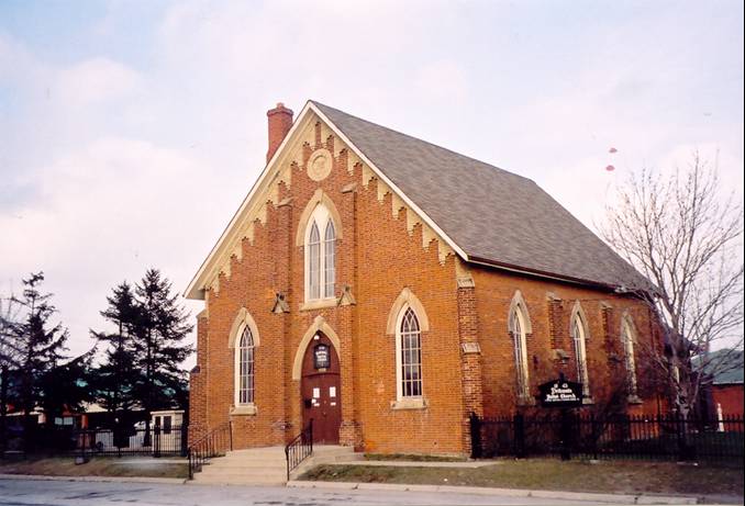
By 1830, many more families had begun to settle around the crossroads of Centre Road and what would become known as Britannia Road, at one time referred to as the Elmbank Sideroad. It was in that year that Joseph Gardner donated the land for the establishment of a permanent Methodist church and graveyard. The first recorded burial took place in 1837, while the surviving brick church was built in 1843.
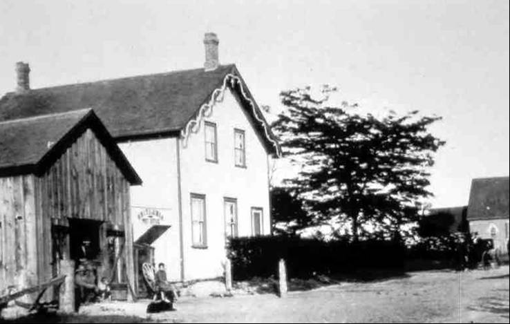
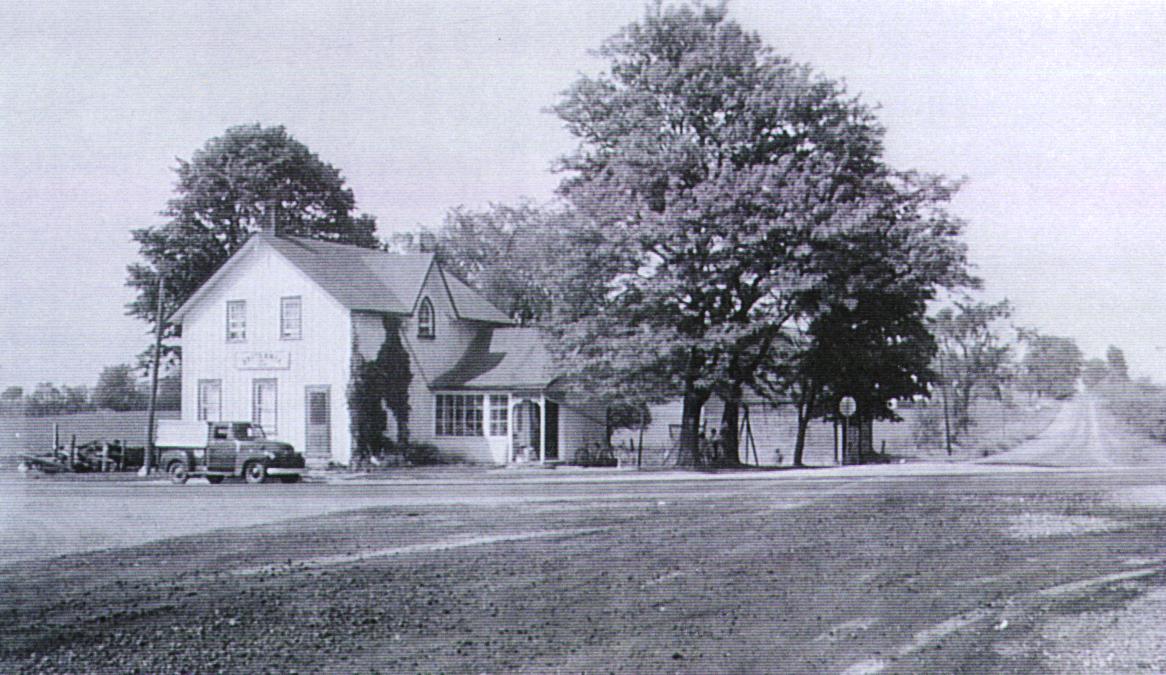
Gardner’s Clearing soon boasted a wagon shop, carpenter shop, a general store and a blacksmith shop. An early blacksmith was George Harris while Thomas Sibbald is named as a carpenter and cabinet-maker. When the first post office opened in 1863, the community officially adopted the name “Britannia”, in honour of British imperial rule. The first post master was Joseph Muir, followed by Joseph Gardner, Arthur Greenius and W. Sawdon. The Britannia post office closed in 1915 when rural mail delivery began.
Among the early prominent settlers in the vicinity was Joseph Gardner. Joseph became a prosperous farmer who raised sheep, pigs, cows, horses, fowl and wheat. He also maintained a large McIntosh apple orchard. Joseph was a staunch Wesleyan Methodist and was instrumental in establishing the Britannia Methodist (now United) Church in 1843. He also served as a Justice of the Peace and his home became known as “Prospect House”. Many of the settlers in the Britannia area were Methodists and supporters of the reform movement in the 1830s. During the Rebellion of 1837, many Britannia families showed strong solidarity with William Lyon Mackenzie, and Robert
Johnston was believed to have sheltered Mackenzie during his escape. Interesting, it was the Britannia Militia, under Amos Wilcox, that was originally dispatched to try and retrieve Mackenzie from Navy Island. Amos’ 1850 home also survives as the Barbizon Restaurant today, at the corner of Eglinton Avenue and Hurontario Street.
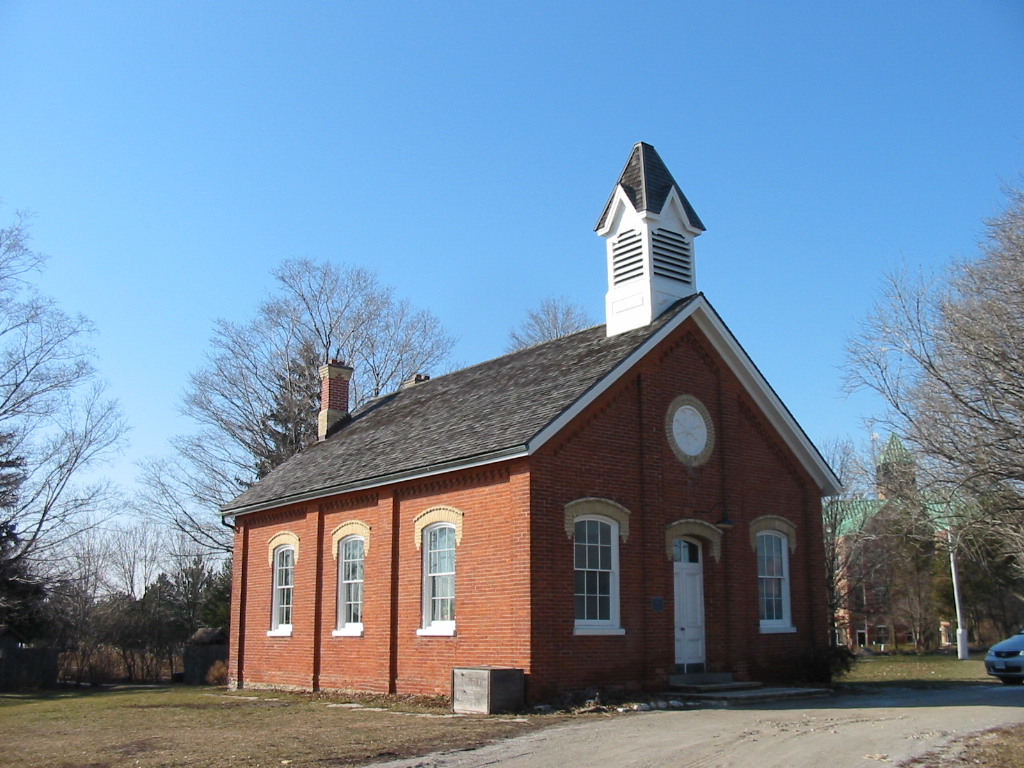
A familiar sight is the one-room Britannia Schoolhouse on the west side of Hurontario Street, just north of Eglinton Avenue. The original log schoolhouse was replaced in 1852 by the surviving brick school. The school was built on land set aside by King William IV for the children of Peel County. The school closed in 1959, and after sitting derelict until 1982, it was restored by the Peel Board of Education and today is lovingly cared for by the “Friends of the Schoolhouse”. Also located on the farm property surrounding the school is a storey-and-a-half farmhouse, typical of the early Peel landscape, and original to the property. Beside it is a larger Georgian-style house, known as the Gardner-Dunton House, which is believed to have been built in 1840 and was relocated to the current property in 1989. The house original stood at the Southwest corner of Britannia Road and Hurontario Street. Also clearly visible along Hurontario Street are the Conover Barn (at the Britannia Farm) and the Madill Barn (located just north of Highway 401). These structures help to root our community memory to a not-so-distant agricultural and rural past.
These are but a few physical remnants of Britannia that survive amidst the modern suburbia and industry of Mississauga. More valuable still are the rich memories and stories of the community that survive, in no small thanks due to the efforts of Britannia residents Marjorie and Ben Madill. In an effort to stir a collective memory, we can look at the names from the historical maps that show Britannia to help stir a collective memory of this lost village; names like Carberry, Docherty, Dunton, Gardner, Johnston, Leary, Little, Lougheed, Madill, Might, Sibbald, Treanor, Waite and Wright, amongst many others. Please share your stories and pictures of Britannia with us.